
13 Colonies Map Lab
A drag-and-drop practice lab for the 13 British Colonies map test: place every colony, starred settlement, and geographic feature, then drill the regions, the Fall Line, and Anglicization.
APUSH · Map Test Prep
13 Colonies Map Lab
The three regions first
The worksheet’s “Color-” task is really a sorting task: every colony belongs to one of three regions. The chips in the first activity are already tinted with these colors, so placing them teaches the coloring for free.
New England
NH · MA · RI · CT
Rocky soil, Puritan towns, cod and shipbuilding. Memory hook: “My Cat Ran North” (MA, CT, RI, NH).
Middle
NY · NJ · PA · DE
Breadbasket colonies, diverse and tolerant. Memory hook: “Nice Jerseys Play Defense” (NY, NJ, PA, DE).
Southern
MD · VA · NC · SC · GA
Cash crops and plantations. Memory hook: “Maybe Virginia Never Sends Gifts” (MD, VA, NC, SC, GA).
Warm-up 1: the 13 colonies
Place the 13 colonies
Chips are tinted by region: purple New England, orange Middle, teal Southern.
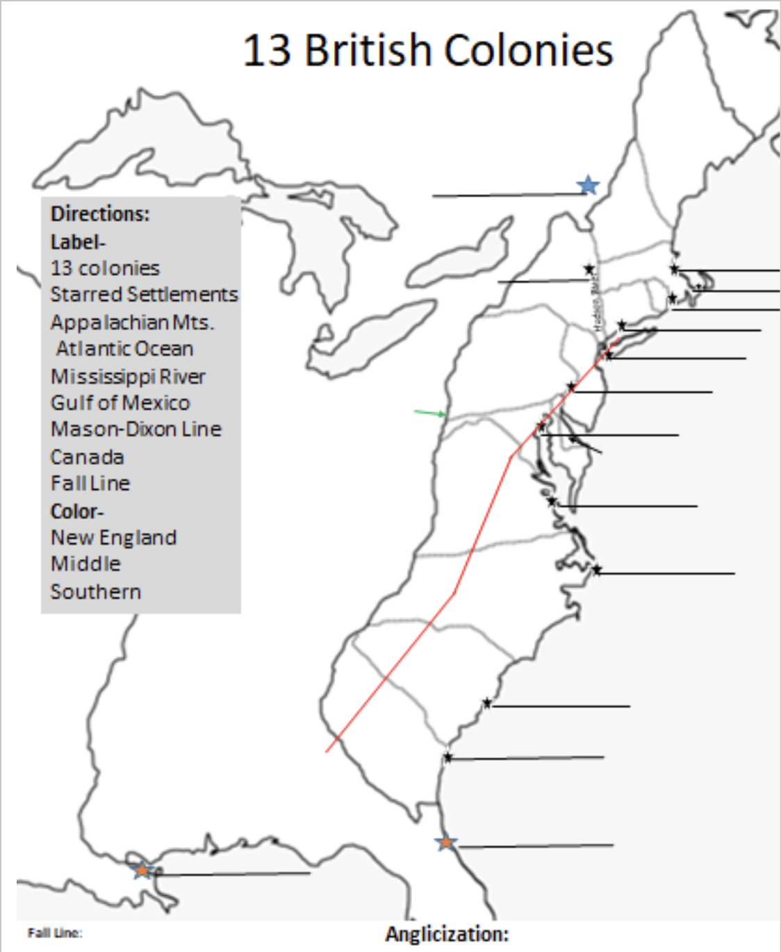
Warm-up 2: the starred settlements
Place the 15 starred settlements
Drop each name onto its blank answer line, just like writing on the worksheet. Black stars are English, blue French, red Spanish.
Settlement cheat table
| Settlement | Where | Whose | Why it matters |
|---|---|---|---|
| Jamestown / Williamsburg | VA | English | 1607, first permanent English settlement; Williamsburg the later capital |
| Plymouth | MA coast | English | 1620, Pilgrims and the Mayflower Compact |
| Boston, MBC | MA | English | 1630, Massachusetts Bay Colony’s Puritan hub |
| Providence | RI | English | 1636, Roger Williams’s haven for religious dissenters |
| New Haven | CT | English | 1638, strict Puritan port town |
| New York / New Amsterdam | NY harbor | Dutch, then English | Dutch 1626; England seized and renamed it in 1664 |
| Albany | Upper Hudson | Dutch, then English | began as a Dutch fur-trading post |
| Philadelphia | PA | English | 1682, Penn’s Quaker city |
| Baltimore | MD | English | Chesapeake tobacco port |
| New Bern | NC | English | Swiss and German settlers on the Carolina coast |
| Charleston | SC | English | 1670, the great southern port city |
| Savannah | GA | English | 1733, Oglethorpe’s planned city in the buffer colony |
| Quebec | St. Lawrence | French | 1608, Champlain’s capital of New France |
| New Orleans | Mississippi mouth | French | 1718, controls Mississippi River trade |
| St. Augustine | FL | Spanish | 1565, oldest European city in the future U.S. |
Warm-up 3: geography and borders
Place the geography, borders, and rival empires
Everything on the worksheet that is not a colony or a town: rivers, mountains, oceans, lines, and neighbors.
Worksheet blank #1
Fall Line
Where rivers tumble off the hard rock of the Piedmont onto the soft coastal plain, making waterfalls and rapids. Ships could sail upriver no farther, so port towns grew there, and it marked the practical western edge of early settlement. On your map it is the red line.
Worksheet blank #2
Anglicization
The process by which the colonies became more English over time: English language, law, courts, consumer goods, and institutions spreading through colonial life. Different colonies, one increasingly shared British culture.
The full worksheet, one shot
Everything at once: 39 chips, Test mode. Place them all, press Check, and chase a perfect score. This is the closest thing to sitting the actual map quiz.
The whole map: colonies + settlements + geography
Test mode. Nothing is graded until you press Check, just like the real thing.
Flashcards
Flashcards
1 / 16 · browse mode
Ratings schedule next review · view all due cards
Last blanks before the test
Speed round
0 of 0 correct
Check against the real key
Q Show my teacher's full answer key
